Remote sensing classification and risk modeling
- •
Unsupervised classification and risk modeling
- •
K-means clustering in remote sensing
- •
Workflow
- •
- •
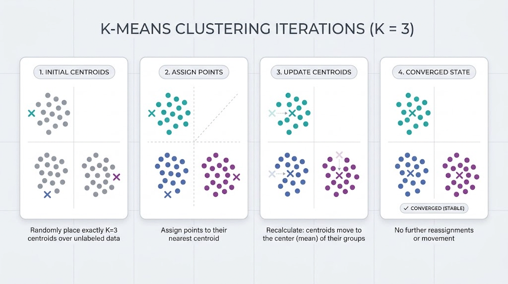
feature selection: select calibrated surface reflectance bands (e.g. Landsat B1-B7) and spatial region of interest.
- •
sampling: extract representative training pixels across the scene.
- •
centroid fitting: fit cluster centers minimizing within-cluster variance .
- •
pixel assignment: assign every raster pixel to its nearest cluster centroid in feature space.
- •
post-classification labeling: interpret clusters into land cover classes using spectral signatures.
- •
validation: evaluate accuracy against ground truth or high-resolution imagery.
- •
- •
- •
- •
- •
Multitemporal change detection
- •
Archive analysis -> track long-term land cover transitions across multi-decade satellite archives (e.g. Landsat 4/5/7 to Landsat 8/9).
- •
- •
Earliest-detection raster mapping
- •
assign year values to target pixels and mask non-target pixels.
- •
apply a temporal minimum reducer (
.reduce(ee.Reducer.min())) across the time series to identify the earliest year a pixel was observed as built-up. - •
semantic caution: represents the earliest recorded satellite detection in the series, not proof of construction date or continuous occupancy.
- •
- •
- •
Temporal comparability cautions
- •
- •
- •
Python implementation: clustering and multitemporal change detection
- •
demonstrates local k-means clustering, earliest-detection temporal aggregation, and correct metri area computation. uses
require_planefrom code 3. - •
import cv2
import numpy as np

def cluster_features(features, k=2, sample_size=500, seed=0):
        a = np.asarray(features, dtype=np.float32)
        if a.ndim != 3 or a.size == 0 or not np.isfinite(a).all():
            raise ValueError("expected finite H x W x bands features, already validity-filtered")
        pixels = a.reshape(-1, a.shape[-1])
        if not isinstance(k, int) or not isinstance(sample_size, int) or not 1 <= k <= sample_size:
            raise ValueError("require integer 1 <= k <= sample_size")
        if k > len(pixels) or not isinstance(seed, int) or not 0 <= seed < 2**31:
            raise ValueError("not enough pixels or unsupported seed")
        rng = np.random.default_rng(seed)
        selected = rng.choice(len(pixels), min(sample_size, len(pixels)), replace=False)
        if len(selected) == 1:
            # OpenCV treats a single-row matrix as scalar samples, not one feature vector.
            centers = pixels[selected].copy()
        else:
            cv2.setRNGSeed(seed)  # OpenCV global RNG: record seed; avoid concurrent reseeding
            criteria = (cv2.TERM_CRITERIA_EPS | cv2.TERM_CRITERIA_MAX_ITER, 100, 1e-4)
            _, _, centers = cv2.kmeans(pixels[selected], k, None, criteria, 1, cv2.KMEANS_PP_CENTERS)
        distances = ((pixels[:, None, :] - centers[None, :, :]) ** 2).sum(axis=2)
        return distances.argmin(axis=1).reshape(a.shape[:2]), centers

def temporal_built_summary(built, valid, years, pixel_area_m2):
        if not isinstance(built, np.ndarray) or built.dtype != bool or built.ndim != 3 or built.size == 0:
            raise ValueError("built must be nonempty Boolean T x H x W")
        if not isinstance(valid, np.ndarray) or valid.dtype != bool or valid.shape != built.shape:
            raise ValueError("valid must match built")
        years = np.asarray(years)
        if years.ndim != 1 or len(years) != built.shape[0] or not np.issubdtype(years.dtype, np.integer):
            raise ValueError("one integer year per time step required")
        if np.any(years <= 0) or np.any(np.diff(years) <= 0):
            raise ValueError("years must be positive and strictly increasing")
        area = require_plane(pixel_area_m2)
        if area.shape != built.shape[1:] or np.any(area <= 0):
            raise ValueError("positive aligned pixel areas required")
        detected = built & valid
        first = np.min(np.where(detected, years[:, None, None], np.inf), axis=0)
        first[~detected.any(axis=0)] = np.nan  # never detected, not year zero
        annual_ha = (detected * area[None]).sum(axis=(1, 2)) / 10000
        coverage_ha = (valid * area[None]).sum(axis=(1, 2)) / 10000
        return first, annual_ha, coverage_ha

features = np.array([[[0., 0.], [0., 0.]], [[1., 1.], [1., 1.]]], np.float32)
labels, centers = cluster_features(features, k=2, sample_size=4, seed=4)
assert labels[0, 0] == labels[0, 1] and labels[0, 0] != labels[1, 0]
single_labels, single_center = cluster_features(
        np.array([[[0., 10.]]]), k=1, sample_size=1)
assert single_center.shape == (1, 2) and np.array_equal(single_center, [[0., 10.]])
assert single_labels.tolist() == [[0]]
built = np.array([[[True, False]], [[False, True]]])
first, annual_ha, coverage_ha = temporal_built_summary(
        built, np.ones_like(built), [1990, 2000], np.full((1, 2), 900.))
assert first.tolist() == [[1990., 2000.]]
assert np.allclose(annual_ha, [0.09, 0.09]) and np.allclose(coverage_ha, [0.18, 0.18])
- •
- •
Multi-criteria environmental risk modeling
- •
Hazard, Exposure, and Vulnerability (HEV) framework
- •
Risk definition -> disaster risk is modeled as the interaction of hazard, exposure, and vulnerability ().
- •
Hazard () -> physical likelihood, magnitude, and spatial extent of dangerous events (e.g. flood inundation).
- •
Exposure () -> population, assets, infrastructure, and land cover located in hazard zones.
- •
Vulnerability () -> socioeconomic susceptibility to harm and capacity to anticipate, cope, and recover.
- •
- •
- •
Factor selection and derivation
- •
Hazard components ()
- •
distance to water bodies: proximity to river channels increases flood potential (descending score).
- •
elevation: low elevation accumulates runoff (descending score).
- •
Topographic Position Index (TPI): relative topographic depressions (negative TPI) pool water.
- •
Vegetation cover (NDVI): low vegetation or high impervious cover accelerates surface runoff.
- •
terrain slope: flat terrain impedes drainage, heightening pooling hazard.
- •
- •
- •
- •
- •
Risk index aggregation
- •
Sensitivity analysis and model limitations
- •
Sensitivity testing -> evaluate model stability against variations in factor weights and classification cutoffs.
- •
Index vs hydraulic modeling -> multi-criteria harkat scoring provides relative spatial rankings of indicative risk; it does not simulate fluid mechanics or output calibrated physical flood depths/probabilities.
- •
Empirical validation -> validate predicted risk hotspots against historical flood inundation footprints and damage records.
- •
- •
- •
Python implementation: multi-criteria risk modeling
- •
computes ordinal harkat scores, combines multi-criteria risk models, and summarizes class areas in hectares. reuses
require_planeform code 3 - •
import numpy as np def harkat(values, cuts, descending=False): x = require_plane(values) cuts = np.asarray(cuts, dtype=np.float64) if cuts.shape != (4,) or not np.isfinite(cuts).all() or np.any(np.diff(cuts) <= 0): raise ValueError("four finite strictly increasing cuts required") score = 1 + (x[..., None] > cuts).sum(axis=-1) return (6 - score if descending else score).astype(np.uint8) def flood_model(distance, dem, tpi, ndvi, exposure, vulnerability, slope, valid, slope_weight=0.2, slope_cuts=(2, 8, 15, 30)): planes = list(map(require_plane, (distance, dem, tpi, ndvi, exposure, vulnerability, slope))) if len({x.shape for x in planes}) != 1: raise ValueError("all model variables must have the same grid") distance, dem, tpi, ndvi, exposure, vulnerability, slope = planes if not isinstance(valid, np.ndarray) or valid.dtype != bool or valid.shape != dem.shape: raise ValueError("a common Boolean validity mask is required") if np.any(distance < 0) or np.any(slope < 0): raise ValueError("distance and slope cannot be negative") if any(np.any((x < 1) | (x > 5) | (x != np.rint(x))) for x in (exposure, vulnerability)): raise ValueError("E and V must be previously classified integer scores 1..5") if not np.isfinite(slope_weight) or not 0 <= slope_weight <= 1: raise ValueError("slope weight must be in 0..1") scores = [harkat(x, cuts, descending=True) for x, cuts in ( (distance, (50, 100, 150, 200)), (dem, (5, 10, 15, 20)), (tpi, (-0.75, -0.5, -0.25, 0)), (ndvi, (-0.25, 0, 0.25, 0.5)))] hazard_sum = np.stack(scores).astype(np.float64).sum(axis=0) H = harkat(hazard_sum, (4, 8, 12, 16)) r2, r3 = H + exposure, H + exposure + vulnerability slope_score = harkat(slope, slope_cuts, descending=True) new_hazard = hazard_sum / 4 * (1 - slope_weight) + slope_score * slope_weight weighted = 0.5 * new_hazard + 0.3 * exposure + 0.2 * vulnerability outputs = {"H": H, "r2": r2, "r3": r3, "weighted": weighted, "k2": harkat(r2, (2, 4, 6, 8)), "k3_literal": harkat(r3, (2, 4, 6, 8)), "k3_table": harkat(r3, (2, 6, 9, 12)), "k2_mean": harkat(r2 / 2, (1.8, 2.6, 3.4, 4.2)), "k3_mean": harkat(r3 / 3, (1.8, 2.6, 3.4, 4.2)), "weighted_class": harkat(weighted, (1.8, 2.6, 3.4, 4.2))} return {name: np.where(valid, x, np.nan) for name, x in outputs.items()} def class_area_ha(classes, pixel_area_m2): classes = np.asarray(classes, dtype=np.float64) area = require_plane(pixel_area_m2) if classes.shape != area.shape or np.isinf(classes).any() or np.any(area <= 0): raise ValueError("aligned classes and positive pixel areas required") ok = np.isfinite(classes) if np.any((classes[ok] < 1) | (classes[ok] > 5) | (classes[ok] != np.rint(classes[ok]))): raise ValueError("valid classes must be integer labels 1..5; NaN means unavailable") return {k: float(area[classes == k].sum() / 10000) for k in range(1, 6)} cuts_example = np.array([[50., 100., 150., 200., 201.]]) assert harkat(cuts_example, (50, 100, 150, 200), True).tolist() == [[5, 4, 3, 2, 1]] plane = np.ones((1, 2)) risk = flood_model(plane * 250, plane * 25, plane, plane * 0.6, plane, plane, plane * 35, np.array([[True, False]])) assert risk["r2"][0, 0] == 2 and risk["r3"][0, 0] == 3 assert risk["k3_literal"][0, 0] == 2 and risk["k3_mean"][0, 0] == 1 assert risk["weighted"][0, 0] == 1 and np.isnan(risk["weighted"][0, 1]) assert class_area_ha(risk["weighted_class"], plane * 900)[1] == 0.09 - •
- •